
Windheads are whimsical faces blowing air from the corners or edges of old maps. They are often puff-cheeked. These features are among the most charming and iconic of early Western cartography. Today, they are largely obsolete. Modern scientific notation and satellite imagery have replaced them. Windheads once served an important symbolic and functional role in geographical representation. Their history includes graphic art and visual metaphor. It also encompasses medieval cosmology. Furthermore, it involves Renaissance imagination and Enlightenment rationality.
In this post, we’ll explore what windheads are and their symbolic and practical uses. We’ll also look into their origin and evolution in mapping traditions. Lastly, we will discuss the period when cartographers gradually abandoned them. Understanding windheads allows us to better appreciate the intersection of art, science, and mythology in historical mapmaking.
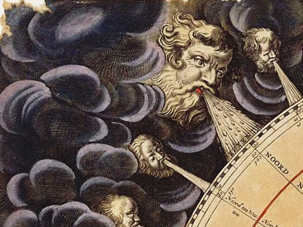
What Are Windheads?
A windhead is a decorative element. It features a human or mythological face with puffed cheeks. The face is often shown in profile or frontally, blowing wind from its mouth. These faces are typically arranged around the borders of a map, especially in the cardinal or intercardinal directions (e.g., north, northeast, east, etc.), and they represent winds or directional forces.
Windheads go by various names depending on the context. In mythological settings, they are also known as wind faces, wind gods, or wind deities. In cartography, though, they are primarily symbolic depictions of directional winds. They are sometimes labeled with their classical or regional names, like Boreas for the north wind in Greek mythology.
Windheads were sometimes purely decorative. But, they often held real informational value in early nautical and cosmological maps. They provided clues about prevailing wind directions or the presumed breath of divine forces shaping the Earth.

Symbolic and Functional Uses of Windheads
Windheads served several overlapping purposes in early mapmaking:
1. Windheads Indicating Wind Direction
One of the primary uses of windheads was to show wind direction—particularly on sea charts or portolan maps. Mariners relied on knowledge of prevailing winds for navigation, and windheads offered a mnemonic or visual shorthand for these forces. Some maps labeled each windhead with names from Greek, Roman, or later medieval traditions of wind roses.
2. Representing Cosmological Forces
In pre-modern cosmologies, natural elements like wind were seen as the breath of divine entities or cosmic energies. Windheads often personified these forces. They were depicted as classical gods, like Aeolus or Zephyrus. In Christianized versions of the motif, they appeared as angelic beings. Their presence helped reinforce a worldview where Earth was governed by spiritual and natural harmonies.
3. Ornamentation and Aesthetic Framing
From the Renaissance onward, they also served as rich ornamental features that framed maps with drama and motion. These faces, often stylized with flowing hair and spiraling breath, added visual interest to otherwise static representations. Their role as artistic devices was crucial. It was closely tied to the humanist and mythological interests of the era’s mapmakers and their elite patrons.
4. Windheads as Instructional Tools
In educational or encyclopedic maps, windheads provided visual cues. This was particularly true in the early printed atlases of the 15th and 16th centuries. These cues helped readers understand the relationship between geography, the elements, and ancient natural philosophy.

Windheads Origins and Historical Development
Classical and Pre-Map Traditions
The idea of wind personifications predates cartography itself. In ancient Greece, winds were deified as the Anemoi. Each represented a specific direction and temperament: Boreas (North), Notus (South), Zephyrus (West), and Eurus (East), among others. These were often depicted in Greek art, especially in architectural reliefs and manuscripts.
The Tower of the Winds in Athens, built in the first century BCE, is a classic example. It is an octagonal building. The building is topped by sculpted figures of the wind gods. These figures are blowing in from eight directions. This fusion of artistic and functional design influenced later mapmaking.
Windheads First Appearance on Maps
Windheads began appearing on maps in the 13th and 14th centuries, with their use becoming widespread in the 15th century. Some of the earliest known examples can be found in medieval mappa mundi. Large, circular world maps like the Hereford Mappa Mundi (c. 1300). These maps, created in monastic or courtly settings, were less concerned with geographical accuracy than with symbolic representation. In this context, windheads served both theological and cosmological functions.
With the emergence of portolan charts—navigational maps developed by Mediterranean sailors from the 13th century onward—windheads became more practical. Early portolans emphasized compass roses and rhumb lines. Decorative windheads soon adorned the corners and edges of later examples.
The Renaissance and Humanist Cartography
The 15th and 16th centuries marked the golden age of windheads in cartography. European cartographers like Ptolemy, Mercator, and Ortelius merged classical learning with new geographical knowledge. Windheads became visual bridges between science and myth.
- Ptolemaic revival maps often included windheads labeled with the classical Greek or Latin wind names.
- The Nuremberg Chronicle (1493), an illustrated world history, includes maps with personified winds.
- In Abraham Ortelius’s Theatrum Orbis Terrarum (1570), windheads blowing toward the continents. The map margins showcase this feature. It is widely regarded as the first modern atlas.
- Gerardus Mercator, known for his projection technique, also used them in early globes and decorative panels.
These figures served to animate the maps. They linked terrestrial geography with ancient cosmology. This appealed to the tastes of Renaissance scholars and patrons.

Decline and Disappearance of Windheads
The use of windheads began to decline in the 17th century. During this period, mapmaking evolved from a blend of myth, art, and empirical knowledge. It transformed into a more scientific and mathematical discipline.
Rationalism and the Scientific Revolution
The Scientific Revolution brought new instruments and techniques of observation. Barometers, telescopes, and better navigational tools made symbolic representations like windheads seem antiquated. Directional information was now conveyed more precisely through compass roses, longitude and latitude grids, and textual notations.
Mechanistic views of nature gained dominance. This was especially clear in the works of Newton and Descartes. As a result, little room was left for allegorical or personified depictions of natural forces. The idea that winds were the breath of gods no longer aligned with prevailing scientific explanations.
Print Culture and Standardization
As printing became widespread, maps were produced for broader markets—governmental, commercial, and educational. As a result, the need for decorative or mythological imagery declined. Atlases of the 18th century are more sober. Those by Johann Baptist Homann or Guillaume Delisle are technical in tone. They focus on boundaries, transportation, and topography.
By the early 19th century, they had all but disappeared from serious cartography. They survived in a few nostalgic or artistic reprint editions but were functionally obsolete.

Legacy and Modern Usage
Though no longer used in practical maps, windheads persist culturally significant. They are often referenced or revived in historical reconstructions. They often appear in fantasy cartography and educational contexts to evoke the aesthetics of the Age of Discovery.
In the world of graphic design and thematic map illustration, windheads are used for stylistic purposes. They offer a sense of historical continuity and artistic charm.
They also in:
- Tapestries and murals inspired by old maps.
- Museum exhibitions on cartography and the Renaissance.
- Fantasy literature and role-playing games, where they signal a blend of realism and mythology.

Conclusion
Windheads represent a captivating chapter in the history of cartography. As personifications of the wind, they served practical purposes by guiding mariners. They also had symbolic roles, evoking divine presence, and artistic roles, embellishing maps during the Middle Ages and Renaissance. Their decline in the 17th and 18th centuries reflects the broader shift in worldview from mythic cosmology to scientific empiricism.
Today, windheads are functionally obsolete. Yet, they remind us of a time when maps were not only tools for navigation. They also served as windows into how people understood the universe. They are emblems of a lost cartographic imagination—where art, science, and myth coexisted on the same parchment.