

Introduction
The story of Rupes Nigra—Latin for “Black Rock”—is a fascinating blend of early geography, medieval myth, and Renaissance cartographic imagination. Rupes Nigra was allegedly a towering magnetic mountain located at the North Pole. It persisted for centuries on European maps. This legend captivated explorers and scholars alike. Its legend reflects early misconceptions of Earth’s geography. It also shows the evolving role of cartography in shaping and expressing human curiosity, belief, and empirical knowledge.
Rupes Nigra holds a pivotal position. It is mentioned in the lost travelogue Inventio Fortunata. Also it shows up in the enigmatic cartographic masterpieces of Martin Behaim, Gerardus Mercator, and Olaus Magnus. It sits at the intersection of myth and measurement. This phantom landmark challenges the boundary between imagination and observation.
The Origin: Inventio Fortunata and the Birth of the Rupes Nigra Myth
The earliest known mention of Rupes Nigra comes from a mysterious 14th-century book. The book is titled Inventio Fortunata (“The Discovery of the Fortunate Isles”). It was reportedly written by a Franciscan friar from Oxford. This friar traveled to the Arctic regions under royal patronage. Although the text itself is lost, its contents were summarized in letters and later in geographic lore.
According to the account relayed by Jacobus Cnoyen, the North Pole was a sea surrounded by four large islands. Gerardus Mercator later cited this account. The islands were divided by massive rivers flowing inward. At the center of these whirlpools stood a vast black magnetic rock. It was 33 leagues in circumference. The rock was “so high that it could not be seen without great difficulty.” This rock was believed to be the source of magnetic attraction, explaining the behavior of compass needles.
Mercator referenced Inventio Fortunata directly in a letter to John Dee in 1577. He included its contents in his 1595 map of the North Pole. This map also featured the fabled Rupes Nigra.
Martin Behaim and the 1492 Erdapfel
One of the earliest surviving globes is Martin Behaim’s Erdapfel (1492). It offers a glimpse into how geographers viewed the North Pole in the age of exploration. The globe does not explicitly include Rupes Nigra. Nevertheless, it reflects the speculative geography of the Arctic region. This region is dominated by mythical islands and unverified sources.
Behaim, influenced by Ptolemaic geography and reports like those in Inventio Fortunata, relied heavily on traveler’s tales and conjectural data. His globe depicted the world not as it was. Instead, it was imagined and pieced together from merchants’ narratives. It also included biblical lore and classical texts. The Erdapfel does not showcase Rupes Nigra. Yet, it laid the foundation for a generation of maps. In these maps, myth played a significant role in representing unknown regions.
Olaus Magnus and the Carta Marina (1539)
The Carta Marina was created by Olaus Magnus in 1539. It is among the most detailed early representations of Scandinavia and the North Atlantic. Magnus primarily focuses on the Nordic countries. Nonetheless, he also portrays parts of the Arctic as inhabited by strange beasts. These areas are shown with mysterious features.
Rupes Nigra does not prominently appear in the Carta Marina. Nonetheless, the map reveals a broader medieval worldview. In this view, the northernmost regions of the Earth were linked to both marvel and menace. The seas swirled with krakens, icebergs, and frozen wastes; islands appeared and disappeared according to the tides or imagination. It set the stage for more precise—though still speculative—representations in the century to follow.
Gerardus Mercator included Rupes Nigra in his 1595 Map of the Arctic
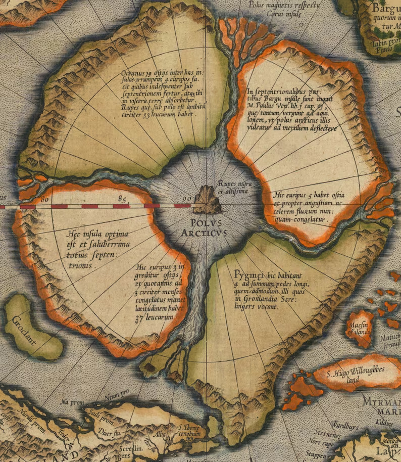
Gerardus Mercator was one of the greatest cartographers of the Renaissance. He included Rupes Nigra in his 1595 posthumous map titled “Septentrionalium Terrarum Descriptio” (Description of the Northern Lands). This map is the most influential visual representation of Rupes Nigra and provides an extraordinarily detailed Arctic.
Mercator shows the North Pole as a sea (Mare Glaciale). It is surrounded by four large landmasses. Each landmass is separated by rivers flowing inward. At the very center is the imposing Rupes Nigra—massive, black, and magnetic. The composition is informed by Inventio Fortunata. Mercator references this in a detailed legend at the bottom left of the map. According to this text, the whirlpool current flowing inward was so strong that ships can hardly escape its pull. The magnetic mountain explained the behavior of the compass and gave geographic coherence to the otherwise mystifying Arctic.
It’s important to understand the context. The late 16th century was an age when empirical science was growing. It was still deeply entangled with inherited lore. Mercator linked classical sources, travelers’ reports, and analytical geometry. His fusion was revolutionary. Some of his sources—like Inventio Fortunata—were apocryphal.

Hondius and the 1606 First Map of the North Pole
Jodocus Hondius, a student of Mercator’s tradition, published an influential update of the Arctic map in 1606. This “First Map of the North Pole” closely follows Mercator’s vision, including the black rock and the four surrounding islands. Nonetheless, Hondius adds a more decorative, aesthetic quality. Ornate sea monsters, ships, and windheads emphasize the romantic and perilous nature of polar exploration.
Hondius also included newer geographical names, suggesting that he was attempting to blend Mercator’s conceptual geography with updated navigational data. Despite increasing skepticism among scientists, the magnetic mountain persisted on maps well into the 17th century. This persistence was not due to scientific rigor. It was preserved due to the authority and aesthetic legacy of Mercator’s cartographic model.
Gerardus Mercator’s 1620 Arctic Map
In the 1620 edition of Mercator’s Arctic map, his son and later custodians of his atlas published it. Rupes Nigra remained a prominent feature. Yet, by this time, there was a growing dissonance between the map’s representation and navigational reality.
Expeditions by Dutch, English, and Danish explorers into the Arctic during the early 17th century became frequent. They were returning without any evidence of the mountain. These voyages, including those led by Henry Hudson and Willem Barentsz, failed to find the rock. They did not discover any land matching the four-island configuration. Still, cartographers continued to reproduce the magnetic mountain, both out of tradition and the absence of compelling different models.
The persistence of Rupes Nigra reveals much about the epistemology of early modern cartography. Maps were not merely scientific instruments. They were repositories of inherited knowledge. They also served as symbols of authority. Additionally, they were artistic statements about the world’s structure.

The Decline and Disappearance of Rupes Nigra
By the late 17th century, empirical mapping had begun to displace legendary geography. Advances in astronomical navigation allowed for more precise voyages. The widespread adoption of latitude and longitude grids provided standardized mapping systems. Additionally, the increased reliability of maritime charts meant that features like Rupes Nigra no longer be sustained without evidence.
The final blow came with the increased presence of Arctic whalers and explorers. They returned with more reliable accounts of the polar region. By the early 18th century, Rupes Nigra had vanished from most reputable maps. It became a cartographic curiosity—referenced in footnotes and appendices, but no longer accepted as real.
Interestingly, the idea of a magnetic pole survived, though it was relocated to a less dramatic, empirically determined point. The magnetic pole’s actual location shifts over time due to changes in Earth’s core. It is now tracked with precision instruments. This is a far cry from the poetic grandeur of a colossal magnetic mountain.
Affiliate Disclosure: This post contains affiliate links. The Cartographic Institute earns a small commission on qualifying purchases as an Amazon Associate at no additional cost to you.
Conclusion: The Power of Cartographic Myth
The story of Rupes Nigra is not merely about a non-existent rock; it’s a story about the evolution of knowledge. It highlights the interplay between empirical observation and inherited belief, between data and imagination. As a cartographic legend, Rupes Nigra embodies the exploratory spirit of early modern Europe. It signifies a world seeking order in chaos and magnetism in mystery.
From the pages of Inventio Fortunata, we see the meticulous etchings of Mercator and Hondius. The phantom black rock at the top of the world reveals how maps can be both mirrors and myths. For historians and cartographers, it serves as a reminder. Even the most authoritative charts are shaped not just by the land and sea they depict. They are also formed by the minds and myths of those who draw them.
A very good read, thank. I am planning an expedition in a small sailboat to search for the Rupes Nigra, and the entrance to inner earth. No i am not mad. Just a man with an adventure in his heart!
What a load of garbage.
The only people you are gaslighting are yourselves.
Earth is flat.
Flat earth, with a hole? Could work.